


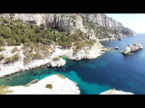
The long video: Morgiou and Sugiton via the Falaise des Toits
The canonical library entry points to a long YouTube video covering Morgiou and Sugiton via the Falaise des Toits. The primary video description identifies a difficult hike with an approximately ten-metre chain-assisted descent, a fissure passage and metal equipment. It also states that footage was captured with a GoPro Hero10 in 4K at 60 frames per second.
These details are valuable because they come from the primary source itself. The dossier can therefore keep the recorded experience separate from the present-day access and conservation rules published by Calanques National Park.
A spectacular route with genuinely technical passages
A chain-assisted drop of roughly ten metres is not a decorative feature. It indicates a section where hand use, coordination and management of exposure matter more than on an ordinary path. A fissure and metal aids do not by themselves establish a climbing grade, but they clearly place the filmed route beyond a simple walk to a viewpoint.
The National Park recommends good footwear, abundant water, sun protection and staying on trails. On sun-heated limestone with limited shade, dehydration and heat can be as important as elevation gain. Technical moments should therefore be interpreted within the duration of the whole outing rather than as isolated dramatic clips.
Sugiton: visitor numbers have become a management issue in their own right
The Park explains that Sugiton and Pierres Tombées suffer strong erosion from over-visitation, with peaks of 2,500 visitors per day. Repeated foot traffic moves soil toward the beach, exposes old pine roots and prevents young plants from establishing.
In 2026, free mandatory reservation applies on 20-21 June, every day from 27 June to 30 August, then 5-6 and 12-13 September. This is a clear demonstration of why older video cannot serve as a permanent legal guide: the landscape may look unchanged while access rules evolve.
Why 2,500 visitors per day creates a spatial problem
The number does not mean 2,500 people are present simultaneously. It is a daily peak. Yet if each visitor makes thousands of footsteps through narrow corridors, pressure repeatedly falls on the same soil. Erosion therefore depends on cumulative passage, not just the number of people visible in one frame.
Wildfire closure overrides a valid reservation
The Park states that when forest areas are closed because of wildfire risk, Sugiton reservations are cancelled. This establishes a clear safety hierarchy: a booking never overrides an emergency access closure.
Practical rules also prohibit fire, bivouacking and camping in this context. Visitors must take waste away and remain on paths and regeneration zones. These constraints are central in a dry Mediterranean landscape receiving intense recreational pressure.
4K60, stabilisation and perception of terrain
The video description identifies GoPro Hero10 footage in 4K60. “4K” refers to high image resolution; “60” means roughly sixty frames per second. A high frame rate can make fast movement easier to read and produce smoother playback, but it does not make the physical passage easier.
Action cameras also use wide fields of view and strong electronic or optical stabilisation. The result is immersive, yet distances and steepness can look different from human vision. On a chain-assisted step, video is useful for understanding the general movement but not for measuring height or deciding that a handhold will be easy for every visitor.
An urban-edge national park is still demanding natural terrain
The Calanques sit next to a major metropolitan area. That proximity creates a striking transition: a visitor can leave Marseille and rapidly enter cliffs and coves where drinking water, shade and easy escape routes are limited. Heavy visitation does not make the landscape ordinary; it increases the conservation challenge.
The film captures the continuity of effort, rock and Mediterranean views. Park documents add information that footage cannot preserve through time: reservation systems, closures, wildfire risk and vegetation-recovery zones. Both source types are necessary for a current documentary page.
Verification workshop: separating the video, the route and the right of access
Sugiton requires three distinct layers. First is the video: it records a real outing and identifies several obstacles. Second is the route: a present-day hiker must verify whether the intended path corresponds to the sections seen, because variants exist between Morgiou, Sugiton, Falaise des Toits and approaches from Luminy. Third is legal access: even a perfectly understood route can be restricted or closed on a specific date.
This separation prevents opposite errors. A Sugiton reservation does not necessarily authorise every technical variant in the Calanques, while an old video does not prove that a route remains freely accessible simply because it was open on filming day. The National Park updates rules, and wildfire danger can close the massif entirely.
A ten-metre chain: order of magnitude, not topographic survey
The primary description says a chain of roughly ten metres. The word “roughly” matters. Without a field measurement or technical route sheet, writing 10.00 m would imply false precision. Scientific reporting should match the number of displayed digits to the quality of the underlying measurement.
The same principle applies to video duration. A twenty-two-minute edit does not mean the hike lasts twenty-two minutes. Audiovisual time selects and compresses experience, so directly comparing film duration with route duration would have no physical meaning.
Reservation as an ecological restoration tool
Sugiton’s quota is not only visitor-comfort management. The Park explicitly links it to slowing erosion and enabling vegetation recovery. This is an important conservation model: protection does not always require permanent closure. A measured seasonal reduction in use can create the conditions for natural regeneration while preserving opportunities to visit.
A documentary video page can therefore record a public-policy change around the same landscape. Footage shows the place; 2026 rules show how society is now trying to limit its own physical impact on that place.
A final check: route difficulty and environmental pressure share the same narrow corridors
Technical terrain and conservation can interact directly. Narrow passages concentrate people, and popular viewpoints encourage repeated stepping on the same strips of soil. A hiker looking for a safer line can also be tempted to leave the established path, potentially widening erosion. Staying on the intended route is therefore both a safety habit and a conservation action where the Park marks regeneration zones.
The Calanques illustrate a wider principle: outdoor access is sustainable only when individual choices remain compatible with collective pressure. One person’s detour looks negligible; thousands of repeated detours can reshape a slope.
This is also why a spectacular chain section should not become the only reason to choose the route. The complete outing includes approach, heat, navigation and the return journey, all of which must fit the group’s abilities.
Sources and verification
- Davious03 Aventures — Morgiou and Sugiton, long version: primary video, route description and camera details.
- Calanques National Park — Sugiton reservations: erosion, visitor pressure and 2026 calendar.
- Calanques National Park — practical information: safety, water, fire, camping and closure rules.
- Calanques National Park — Sugiton: access, viewpoint and site context.